Revolutionary War Sites
Celebrate the 250th anniversary of the United States by visiting these notable Revolutionary War-era sites here in Lake Hartwell Country, South Carolina!
Though many of the most famous Revolutionary War battles and stories focus on New England, the Southern colonies played a critical role in securing our independence from Britain. Around 1778, the British began to concentrate their efforts more firmly on the Southern Theater of war, fighting our Continental troops across Virginia, Georgia, North Carolina, and, of course, here in South Carolina. In 1780, the Continental forces were defeated in Charleston and Camden, but battles near us in the Upstate - such as Cowpens and Kings Mountain - proved to be underdog victories for the colonists, weakening the overall strength of British troops and ultimately helping lead to their surrender in Yorktown, Virginia, in 1781.
Anderson, Oconee, and Pickens Counties contributed many soldiers and commanders to the American Revolutionary effort, and today you can still see their legacies across Lake Hartwell Country.
Revolutionary War Sites
Benjamin Cleveland Marker
GPS Coordinates:
34° 36.783′ N, 83° 11.617′ W
Colonel Benjamin Cleveland was a Revolutionary War hero, helping to lead the Overmountain Men to victory in the battle of Kings Mountain. Photo courtesy of Historical Marker Database.
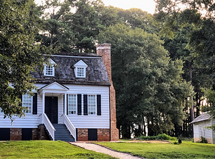
Hanover House
150 Garden Trail OR 530 Garden Trail Clemson, SC 29634
Built in 1716, the Hanover House is a French Huguenot house that was originally constructed in present-day Berkeley County in the South Carolina Lowcountry. It was moved to its current location in the 1940s. Photo courtesy of the Hanover House.
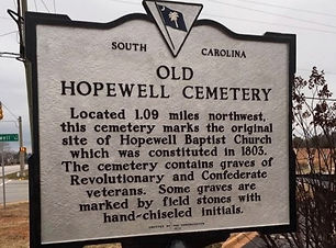
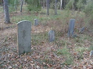
Old Hopewell Cemetery
GPS Coordinates:
34° 35.811′ N, 82° 36.994′ W
The original site of Hopewell Baptist Church was home to this cemetery. Among the church's congregants buried here are several Revolutionary War-era veterans and civilians. Photo courtesy of Historical Marker Database.
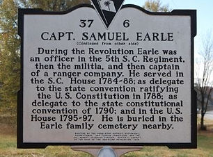
Samuel Earle Marker
GPS Coordinates:
34° 33.967′ N, 82° 59.5′ W
Captain Samuel Earle was an officer during the American Revolution, as well as a state and U.S. representative. He lived at nearby Beaverdam Plantation and is buried in the private Earle family cemetery, located near this marker in Oconee County. Photo courtesy of Historical Marker Database.
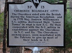
Cherokee Boundary Marker
GPS Coordinates:
34° 51.917′ N, 83° 6.286′ W
During the Revolutionary War, many Cherokee sided with the British. In 1776-77, Major Andrew Williamson and his militia drove the Cherokee out of their towns, forcing them to cede most of their land in South Carolina to the colonists. Photo courtesy of Historical Marker Database.

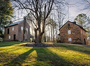
Hopewell Plantation
GPS Coordinates:
34.654279, -82.836720
The Hopewell Plantation was built prior to 1776 and was home to Andrew Pickens Jr., the son of Brigadier General Andrew Pickens and later 46th governor of South Carolina. Photo courtesy of Clemson University.
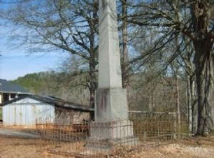
Old Pickens Cemetery
GPS Coordinates:
34° 44.35′ N, 82° 35.467′ W
Near Easley is the Old Pickens Cemetery, established in 1785 behind the Pickens Chapel Church. Between 25-30 Revolutionary War soldiers are buried here, including Captain Robert Pickens. Photo courtesy of Historical Marker Database.
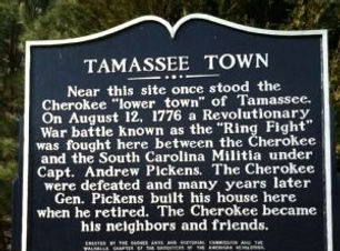
Tamassee Town (Ring Fight) Historical Marker
GPS Coordinates:
34° 52.98′ N, 83° 2.91′ W
This marks the site of the "Ring Fight" on August 12th, 1776, which was fought by the Cherokee and the South Carolina Militia under Andrew Pickens. Photo courtesy of Historical Marker Database.

Fort Rutledge
GPS Coordinates:
34.669173, -82.850841
Fort Rutledge is the site of the Battle of Seneca Old Town, which took place in 1776. Some say Clemson University's Tillman Hall stands on the site of Fort Rutledge, while others believe the site is underwater or located along Lake Drive. Information and photo courtesy of Clemson University.
Oconee Station
500 Oconee Station Road
Walhalla, SC 29691
Oconee Station State Historic Site is managed by South Carolina State Parks. There were Revolutionary War skirmishes that took place in the area around Oconee Station. Photo courtesy of South Carolina State Parks.
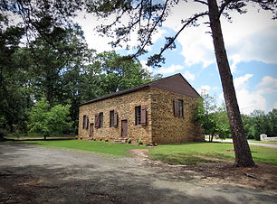
Old Stone Church
101 Stone Circle
Clemson, SC 29631
Completed in 1802, Old Stone Church is the final resting place of Brigadier General Andrew Pickens and Colonel Robert Anderson, both of whom were crucial leaders in the Revolutionary War. Photo courtesy of Old Stone Church.

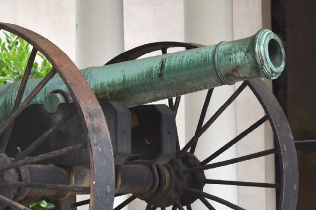
The "Old Reformer"
202 East Greenville Street
Anderson, SC 29621
Located outside of the Anderson County Museum, the cannon nicknamed "Old Reformer" was used in the Revolutionary War and perhaps even the War of 1812. It is estimated to have been built in the 1760s. Photo courtesy of the Anderson County Museum.
